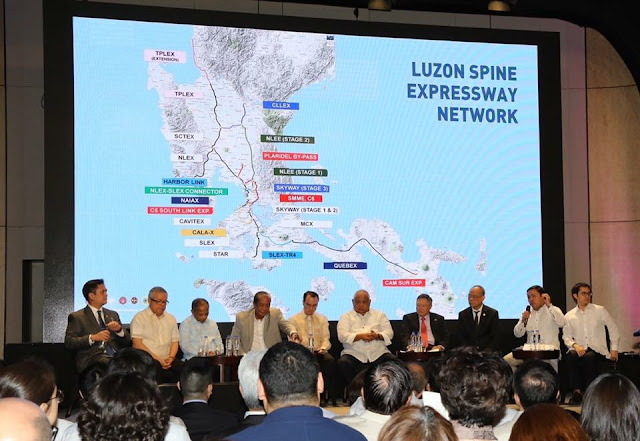
An eight-hour travel time from the northern part of Luzon to its tip down south and an inter-island linkage connecting the whole Philippines is the ultimate dream for the country. A dream that will no longer be a pipeline dream come 2022, according to the head of the implementing agency of the ambitious Build, Build, Build infrastructure program.
FROM NORTH TO SOUTH UNDER 10 HOURS
“One day, that’s one of my goals, before I leave as the secretary, I’ll take one ride from north to south and I hope it won’t take me more than 10 hours,” Department of Public Works and Highways Secretary Mark Villar said.READ: Drive Ilocos to Bicol in eight hours soon!
Loading...
That statement of the secretary sums up the whole infrastructure plan for the country and its people – to make life a little easier for Filipino in terms of travelling from one point to another.
Building a better Philippines has become the department’s mantra in realizing its strategic infrastructure program that is focusing on three major outcomes – to reduce travel time, improve road safety, and protect homes and properties.
Luzon Spine
 |
| Luzon Spine Expressway Network presentation |
A road design network that is crucial to make the eight-hour dream travel time across Luzon possible is the Luzon Spine Expressway.
Aside from the existing 12 expressways, the government aims to add 18 more expressways in Luzon that will make La Union an eight-hour destination from Bicol, and vice versa. From the existing 385-kilometer road network, the Luzon Spine will be extended into 1,040 kilometers.
Traveling from Tarlac to La Union will be drastically cut from the usual three-hour travel time to only an hour with the construction of the 89-kilometer Tarlac-Pangasinan- La Union Expressway (TPLEX). With this, McArthur Highway will be free up once it is completed this year.
Central Luzon Link Expressway (CLLEX), a 30-kilometer expressway, will connect Tarlac, Cabanatuan City, and San Jose in Nueva Ecija, reducing the usual 70 minute travel time to only 20 minutes by 2020.
The North Luzon East Expressway Stage 1 and 2 (NLEE) will provide a scenic view link for Bigte, San Miguel, Gapan City, and Cabanatuan City.
NLEX Harbor Link Segment 10 that connects Manila to Caloocan, offering an alternate route for vehicles, especially trucks to NLEX, bypassing EDSA, was recently completed. This elevated expressway is a major link that will complete the dream to travel around the metropolis in less than an hour.
To also complete the dream eight-hour travel from north to south Luzon, the 220-kilometer Quezon-Bicol Expressway will make San Fernando, Camarines Sur only to two hours away from Pagbilao, Quezon.
Metro Manila Logistics
Aside from expressways, the government will also build 12 more bridges to serve as alternate routes to major roads in the metro.These bridges have been identified as North and South Harbor Bridge, Binondo-Intramuros Bridge, 2nd Ayala Bridge, Pandacan-Sta. Ana Bridge, San Francisco-F.Zobel Bridge, Sta. Monica-Lawton Bridge, Eastbank-Westbank Bridge 1 and 2, C.Gabriel St. -Mercury Ave. Bridge, J.P. Rizal-Yale, Reposo-Guatemala Bridge, and Kabayan-Katipunan Bridge.
These bridges will be built across the rivers of Pasig, Marikina, and Manggahan Floodway.
Inter-island link
Part of the ambitious infrastructure dream is the goal to link the whole Philippines through the inter-island linkage project starting with the Panay-Guimaras-Negros Island Bridge.A series of inter-island bridge projects that aim to connect Luzon, Visayas, and Mindanao through long-span bridges that have been under study.
 |
| Panay-Guimaras-Negros Island Bridge |
The proposed bridges include Bataan-Cavite Interlink Bridge (28 kilometers), Mindoro-Batangas super Bridge (15 kilometers), Camarines-Catanduanes Friendship Bridge (10.7 kilometers), Luzon (Sorsogon)-Samar Link Bridge (18.2 kilometers), Panay-Guimaras-Negros Link Bridge (19.2 kilometers), 4th Mandaue-Mactan Bridge (0.42 kilometer), Cebu-Bohol Link Bridge (24.5 kilometers), Bohol-Leyte Link Bridge (22 kilometers), Leyte-Surigao Link Bridge (23 kilometers), Negros-Cebu Link Bridge (5.5 kilometers), Panguil Bay Bridge (3.77 kilometers), Guicam Bridge (0.44 kilometer), Davao-Samal Bridge (4.4 kilometers), and three Tawi-Tawi Bridges spanning a total of 0.78 kilometer.
Although most of these proposed projects are still under a feasibility study, Villar noted that what’s important is for the Philippines to have a concrete pipeline in infrastructure.
MINDANAO DEVELOPMENT ROAD NETWORK
In the south, the designed Mindanao Development Road Network worth P98.15 billion aims to drive agriculture business in the region.OTHER INFRASTRUCTURE PROJECTS IN THE PHILIPPINES
- This bridge will connect Panay, Guimaras and Negros islands!
- Luzon Spine Expressway Network - Connecting North and South Luzon
- South East Metro Manila Expressway - is it the most awaited answer to our congested traffic in the metro?
- SKYWAY STAGE 3: All You Need To Know
- List of national infrastructures in Taguig under Build, Build, Build program
- DPWH to start Laguna Lakeshore Road Network Project in December
- SMC to 'revive' Pasig River as part of PAREX project
- NLEX Harbor Link Reduces Travel Time From Quezon To Manila From 2 Hours To 20 Minutes
- Sorsogon Coastal Road is now open
- Clark International Airport new terminal building officially opens
- PH’s virology center to rise in New Clark City
Source: PPP


No comments
Let us know your thoughts!